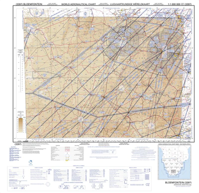
MAPS/2924;Bloemfontein Aero 1:500000
R50,00
Unveiling South Africa’s World Aeronautical Charts: A Pilot’s Guide to Safe Skies
Dominating the southern skies of Africa, South Africa takes the helm in publishing and maintaining a vital set of aeronautical charts. This comprehensive series, encompassing 10 distinct sheets, empowers pilots navigating the vast African airspace. Let’s delve deeper into the specifics of these charts and how they ensure safe and efficient flights.
Detailed Yet Unobtrusive: The 1:500,000 Aeronautical Chart
Each chart within the series boasts a scales of 1:5000000 and 1:1,000,000, offering a clear and concise overview of a significant region. This specific scale prioritizes the most critical details for pilots, ensuring the aeronautical information remains the focal point. Imagine a map that omits unnecessary clutter, focusing solely on the elements crucial for air navigation – that’s the beauty of the aeronautical chart.
Accuracy Reigns Supreme: ICAO-Compliant Information for Trusted Navigation
The International Civil Aviation Organization (ICAO) establishes a global standard for presenting aeronautical information on charts. South Africa adheres meticulously to these guidelines, guaranteeing consistency and clarity across the entire chart series. Pilots can be confident that the navigational aids, air routes, and other essential details displayed on these charts are universally understood and depicted according to established conventions.
Seamless Coverage: A Network of Interlocking Charts
Comprehensiveness is paramount for pilots, and this chart series delivers. Each individual sheet covers a substantial area, encompassing 4 degrees of latitude by 6 degrees of longitude. To eliminate any gaps in coverage, adjacent charts boast a 15-minute overlap in both the north and east directions. This meticulous design ensures pilots have uninterrupted access to the aeronautical information they need throughout their journeys.
Bloemfontein in Focus: A Specific Example
While the above description details the general characteristics of the South African aeronautical charts, let’s use Bloemfontein as a specific example. Imagine a pilot departing from Bloemfontein Airport. They can confidently rely on the corresponding 1:500,000 chart to visualize their flight path, identify nearby navigational aids, and stay informed of designated air routes.
In Conclusion: A Cornerstone of Safety and Efficiency
South Africa’s commitment to producing and maintaining these high-quality aeronautical charts plays a pivotal role in ensuring the safety and efficiency of air travel across southern Africa. Pilots can navigate with confidence, knowing they possess the most up-to-date and reliable information
Related products
-

Map Aero
R50,00 -

-
-